

> PLANET OF THE APPS |
(PDF)
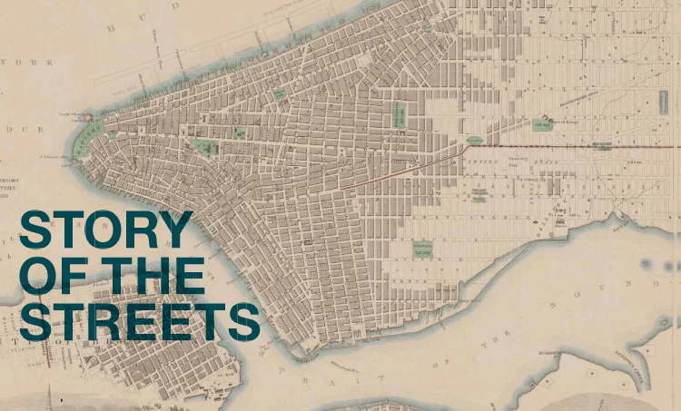
> STORY OF THE STREETS |
(PDF)

> EDITORS’ LETTER
> DOWNLOAD FULL PDF

> GAMING
> LAW
> CUTTING-EDGE
RESEARCH
> DOWNLOAD FULL PDF

> THE INSIDER
> DOWNLOAD FULL PDF

> THEATER
> PLAYLIST
> DOWNLOAD FULL PDF

> NONFICTION
> DOWNLOAD FULL PDF

> PROFILE: HAYES
> PROFILE: ULFERS
> DOWNLOAD FULL PDF
> ABOUT US
> CONTACT US
Many thought New York would never be the same when its audacious grid was planned 200 years ago. They were right.
by Kevin Fallon / CAS ’09
Outside the writer’s window, the din of construction rang as a constant distraction from his work. The newly graded street kicked up dust and gravel, and he feared that what he loved best about New York City would soon be lost to this new development. “[T]hese magnificent places are doomed,” he lamented. “The spirit of Improvement has withered them with its acrid breath.”The writer was Edgar Allan Poe, who, in 1844, managed to compose “The Raven” in a farmhouse at what is now 84th Street and Broadway, despite the full-scale overhaul of Manhattan happening just outside his door. The grid—that sprawling series of parallel avenues running north and south and streets unfolding east and west—had arrived on what would become the Upper West Side. As it crept closer, Poe mourned the loss of the island’s natural, rugged beauty, and the homes dotting its rolling hills. “Streets are already ‘mapped’ through them, and they are no longer suburban residences, but ‘town-lots,’ ” he continued. The farmhouse where he sat would soon be demolished to make way for the grid.
Today the tune has changed; the grid may be the most important and ingenious planning decision in New York City’s history. Two hundred years ago, the crux of the city was crammed south of Canal Street. In 1811, commissioners Simeon De Witt, Gouverneur Morris, and John Rutherfurd announced that they would transform the overcrowded area by imposing an orderly system of roads stretching up through the island’s rural and rocky reaches, from Houston Street to what would become 155th Street. It was a brazen undertaking, and the ensuing decades have seen further pushes: skyward, toward the water, underground, and with added flourishes, from residential plazas like Washington Square to radical additions like Central Park. The framework helped Manhattan’s population balloon from 100,000 to 1.6 million. As Mayor Michael Bloomberg has mused, “It is almost as impossible to imagine New York City without the grid plan as it is to comprehend the audacity of its original ambition.”
And yet those are the goals of The Greatest Grid: The Master Plan of Manhattan 1811-2011 (Columbia University Press), a new book and corresponding Museum of the City of New York exhibit. Both edited and curated by Hilary Ballon, a professor of urban studies and architecture at the Robert F. Wagner Graduate School of Public Service, the book and show reconstruct the original Manhattan and the two centuries of growth since the grid was conceived, using collections of rare surveying maps, historic photos, and documents. “To so many visitors and New Yorkers alike, the grid just seems like the natural condition of the city,” Ballon says. “I wanted to make people denaturalize [it].”
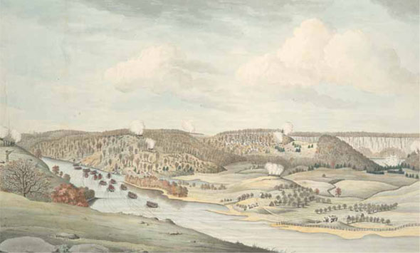
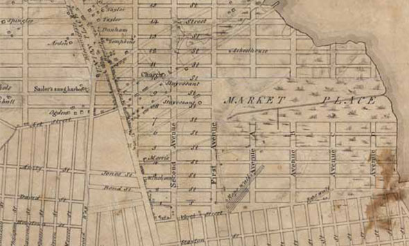
Ballon first had the idea to commemorate the grid in 2007 while working with the Museum of the City of New York on another exhibition—this time celebrating the enterprising New York City planning commissioner and “master builder” Robert Moses. In the intervening five years, Ballon clocked numerous weekends to prepare for the December 2011 opening of “The Greatest Grid” and its corresponding book release, while balancing academic duties on two continents (the professor is also deputy vice chancellor of NYU Abu Dhabi). She drafted a research assistant and nearly two dozen contributors who reviewed 200 years’ worth of dusty documents, photos, and maps. The team resurfaced several treasures, the most exciting of which, for Ballon, were the Randel Farm Maps.
Created by John Randel Jr., the project’s key surveyor, the hand-colored maps show, on a scale of 100 feet to 1 inch, the grid’s topographical outline with the exact measurements of planned avenues and streets—to a painstakingly detailed degree. Roughly 90 maps make up Randel’s entire series, which was discovered in an uncelebrated pile inside the Manhattan Borough president’s office chamber. Ten of those maps were stitched together for the exhibition—the first time they’ve been available to the public—and they will remain on digital file at the museum. “Now students in Manhattan can go on their own block or the block of their school and see how it looked in 1817, when those maps were made,” Ballon says.
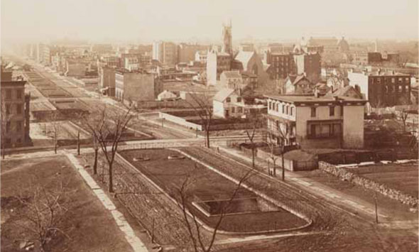
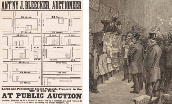
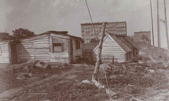
While the maps underline the massive scale of construction, scores of historic photos illuminate the slow, deliberate transition from old-world rural to sleek, angular streets. Pictures from the late 19th century show jumbles of farm buildings sidled next to town houses and apartment buildings, while sweeping avenues are graded and paved around them. The grid took 60 years to finish, and Poe was not the only naysayer. The project required the redrawing of property lines and many New Yorkers saw this as a ploy to steal their land, though they were eventually paid handsomely for their parcels. According to biographer James Parton, John Jacob Astor sold a lot near Wall Street in 1810 for $8,000, and the purchaser celebrated that he would soon make a killing. As the book recounts: “ ‘Why Mr. Astor,’ said he, ‘in a few years this lot will be worth twelve thousand dollars.’ ‘Very true,’ replied Astor, ‘but…[w]ith eight thousand dollars I buy eighty lots above Canal Street. By the time your lot is worth twelve thousand dollars, my eighty lots will be worth eighty thousand dollars;’ which proved to be the fact.”
Other critics bemoaned that “there’s no way architects can survive in this framework,” Ballon says. The grid had no centre ville on which ornate cathedrals could tower, as they do in a European metropolis. There were no axial boulevards, such as one finds in Washington, D.C., Buenos Aires, and Paris, to showcase monuments and public squares. But a casual stroll up a Manhattan avenue—Ballon’s version of a perfect New York City day—reveals “a special kind of architectural genius in that urban system,” she says, where buildings sit cheek to cheek, none outshining another, and creating a city in which the continuous streets become essential to its character. “Pretty much every aspect of Manhattan could be linked back to the grid,” Ballon says.
Some would argue that the plan is also unrivaled in the convenience it spawned, with the grid even becoming a shorthand within the borough. The second-nature lingo of street-and-avenue coordinates—“91st and Second; 34th and Sixth”—instantly places a person directionally within the city, details the character of a neighborhood, and signals whether someone needs to travel north, south, east, or west to get there. “Someone says, ‘I’m at Second and Third,’ ” Ballon says. “How does one know where that is? Which is the avenue? Yet we know. We know.”
For many New Yorkers, it’s also how we plot our lives. Ballon’s father worked on 57th Street and Fifth Avenue (she grew up in Westchester). Her first New York apartment was on Eighth and Broadway. She married her husband on 60th and Fifth, and her current office is on Washington Square North—which, though not an area on the original 1811 grid (it was the site of a cemetery), would eventually become part of the overall plan.
Perhaps it’s because these coordinates tell so many stories that the exhibition attracted the largest audience in the history of the museum, earning a three-month extension and only closing this past July. Sam Roberts at The New York Times wrote, “You don’t have to be a geometry major to love” the book, praising that just as the grid “imposed a Cartesian orderliness on the city,” so “this book does on its subject matter.”
Ballon has her own thoughts on why a subject so historical and academic could be so popular. “I think it lifted a veil from people’s eyes,” she says. “It’s kind of like looking at childhood pictures of your best friend, seeing what she looked like as a child. That revelation of something utterly familiar.”