
LINE | (PDF)
> THE NUMBERS
> THE ROAD TO $3 BILLION
> WHAT YOUR MONEY
BUYS
> UNFINISHED BUSINESS
> KING OF THE
WATERCOOLER | (PDF)
> THE LITTLE DIFFICULT |
(PDF)

> PRESIDENT'S LETTER
> DOWNLOAD FULL PDF

> ECONOMY
> POLITICAL PERSUASION
> NEW POLITICS
> NEW TECHNOLOGY
> CUTTING-EDGE
RESEARCH
> DOWNLOAD FULL PDF

> EMERGENCY RESPONSE
> DOWNLOAD FULL PDF

> COUTURE
> CREDITS
> DOWNLOAD FULL PDF

> NONFICTION
> DOWNLOAD PDF

> PROFILE: GREEN
> DOWNLOAD FULL PDF
> ABOUT US
> CONTACT US
emergency response
Predicting the Unthinkable
catastrophe simulation offers New Yorkers a ‘PLAN C’
by Ted Boscia
Just as those safety booklets in airplane seat–pockets depict passengers placidly slipping on oxygen masks as the plane loses pressure, emergency plans often operate as if people will evacuate from a terrorist attack or natural disaster in an orderly, single–file line.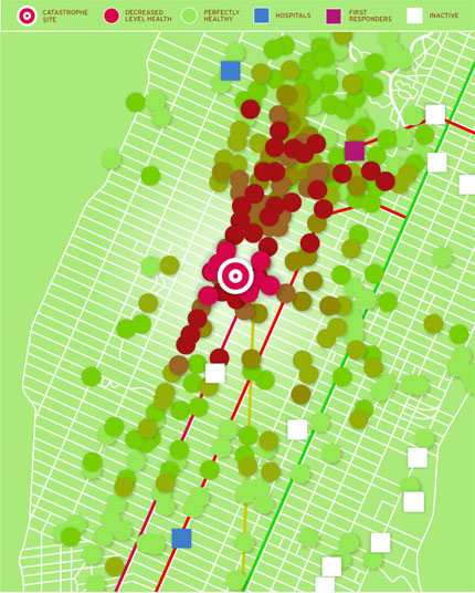 This hypothetical sarin nerve gas disaster, mapped by a Center for Catastrophe Preparedness team, offers planners a visual sense of emergency response over a five–minute period.
NYU researchers have now
advanced emergency preparedness beyond such assumptions with a new digital model that simulates minute by minute how a crisis might unfold. Called PLAN C, or Planning with Large Agent–Networks Against Catastrophes, the software relies on hundreds of
algorithms to calculate response and recovery efforts during a disaster and is the first to allow public–safety officials to test–drive their response ahead of a crisis. “We want to consider the worst case, because that’s what you’ll probably see,” says Ian Portelli, project manager for the Center for Catastrophe Preparedness and Response. “In many other simulations, people don’t have children, they walk straight, there are no wheelchairs, everyone speaks English. That’s not real life.”
To better understand how civilians behave in emergencies, the PLAN C team—a multidisciplinary group with funding from the U.S. Department of Homeland Security that draws on faculty from medicine, psychology, social science, public health, computer science, law, and other areas— studied the outcomes of domestic and international catastrophes such as Hurricane Katrina and the December 2004 tsunami in Sri Lanka and Thailand. They found that people instinctively reach out to loved ones in a crisis, sometimes at their own risk, which means evacuees can take far longer to leave if they must collect family members scattered across a city or region. This knowledge, along with focus group data from first–responders, helped shape the PLAN C algorithms. “It’s hard to predict human behavior,” Portelli admits. “We know how many minutes we’ll have to get you to a hospital to save you. But how will you behave in a vulnerable situation when your child is at school and your wife is across town?”
Along with social dynamics, PLAN C weighs what principal investigator Lewis Goldfrank calls “all the ingredients of a community”—hundreds of variables such as city infrastructure and resources, commuting patterns, and community beliefs. One hypothetical supposes a sarin gas attack on Manhattan’s transportation hubs, including the Port Authority Bus Terminal and Grand Central Terminal. In this case, the PLAN C software displays a Geographic Information System map of the city overlaid with color–coded circles representing hospitals, subway stations, and other landmarks. It shows the real–time crosscurrent of victims fleeing and rescuers approaching the scene, which can help planners determine the optimal locations for staging areas and expose gaps in preparedness.
The team also replicated an outbreak of food poisoning that spread to 8,000 people in Brazil in 1998, and plans to review the literature on responses to last spring’s typhoon in Myanmar and earthquake in China as it relates to the next effort of modeling coastal flooding in New York. The team is currently able to simulate a disaster on the scale of 300,000 casualties (defined as anyone affected physically or psychologically by a calamity) and intends to increase this to one million, while adapting the software for other regions. Goldfrank, who chairs the emergency– medicine department, says: “We can take all the diverse characteristics of a city like New York and make order out of them.”
source: ian portelli